Satellites Are Capturing the Protests, and Just About Everything Else on Earth
As protesters gathered in Washington over the weekend, their march across the city was documented by photography satellites.

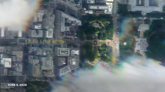
(Bloomberg) -- As protesters gathered in Washington over the weekend, their march across the city was documented by photography satellites flying overhead. One particular image stood out and made its way to various television newscasts. It showed the the bright yellow “Black Lives Matter” mural that had been painted on two blocks of asphalt near the White House. It was visual proof that the protests and their message had, in a sense, made their way to space.
The company that took the photo, Planet Labs Inc., has hundreds of satellites floating around Earth, enough that it can snap at least one photo of every spot on the planet every day, according to the startup. Such imagery used to be rare, expensive and controlled by governments. Now, Planet has built what amounts to a real-time accounting system of the earth that just about anyone can access by paying a fee.
Over the next couple months, Planet is embarking on a project that will dramatically increase the number of photos it takes and improve the quality of the images by 25% in terms of resolution. To do that, the company is lowering the orbits of some of its larger, high-resolution satellites and launching a half-dozen more devices. As a result, Planet will go from photographing locations twice a day to as many as 12 times a day in some places.
Customers will also be able to aim the satellites where they want using an automated system developed by Planet. “The schedule is shipped to the satellite, and it knows the plan it needs to follow,” said Jim Thomason, the vice president of products at Planet.
Advancements like this in satellite imaging would have seemed unbelievable to the folks who started working on such research in earnest in the 1960s. Back then, the U.S. had a top-secret operation that entailed putting satellites into orbit, snapping pictures and then ejecting canisters of film from the satellites that tumbled back to Earth to be caught midair by a plane. Analysts would then develop the film and pore over the images looking for Soviet missile sites and other military operations. This Rube Goldbergian process didn’t always work well, but it did ultimately result in the U.S. learning that the Russian missile program was not as advanced as officials had feared.
Even until recently, many people outside of the government found it difficult and costly to obtain a detailed photo of a particular location. “It’s just this very involved process of negotiating to put a satellite in place,” said Jeffrey Lewis, director of the East Asia Nonproliferation Program at the Middlebury Institute of International Studies, who is well-known for his imagery analysis work. “It could be a few months before you get a picture, and it might cost a few thousand dollars.”
The plethora of satellite photos today has unlocked new business opportunities. Investors, for example, have used images of retailers’ parking lots to count cars and try to determine how busy shops are. However, these data points were limited by, in Planet’s case, two photos a day— one in the morning and another in the afternoon. Whether it’s financial research or chronicling a social-justice movement, more photos means more information to help construct what imagery analysts call patterns of life. “If you can look at a facility day after day and all throughout the day, you learn so much more about it,” Lewis said. “Most people don’t understand how powerful this is because they really haven’t had access to it before.”
Both Planet’s low- and high-resolution satellites have been following the protests in major cities around the world. The satellites have also been tracking the chaotic state of things in recent months. Throughout the pandemic, people have turned to satellite images to monitor slowdowns in activity in cities, check on military activity and follow shipments of goods making their way to ports. Of course, like any powerful technology, Planet’s devices and software can also be put to questionable use. The images are not precise enough to show peoples’ faces but, as the protests show, they are good enough to trace the movement of people and to allow for unchecked intelligence gathering.
Planet’s high-resolution satellites previously took photos where each pixel in the image represented 80 square centimeters on Earth. The new technology will improve the resolution to 50 square centimeters. Although Planet said customer demand for the high-resolution pictures surged 163% over the last year, its images still trail some other companies in quality. Planet also faces a competitive onslaught from other satellite startups delivering new types of images. Capella Space and Iceye, for example, have developed small satellites that can take pictures at night and through clouds using a type of radar.
To try and fend off rivals, Planet has tapped its experience navigating the complexities of the rocket launch industry to get its new satellites up as quickly as possible. Its latest systems will be flown on a pair of rockets from Elon Musk’s Space Exploration Technologies Corp. More launches are planned on rockets taking off from India, New Zealand and French Guiana, said Mike Safyan, the vice president of launch at Planet: “We will never put all of our eggs in one basket.”
©2020 Bloomberg L.P.