How Climate, ‘Rapid Intensification’ Revved Up Hurricane Ida
How Climate, ‘Rapid Intensification’ Revved Up Hurricane Ida
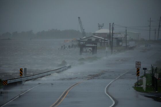
(Bloomberg) -- Many hurricanes grow weaker as they approach land. But Hurricane Ida, like Hurricane Laura in 2020 and a string of other recent hurricanes, did the opposite -- Ida almost doubled its wind speed in the 36 hours before it hit Louisiana. Meteorologists call that kind of deadly shift “rapid intensification,” and say that climate change appears to be making it more common.
1. What counts as rapid intensification?
The National Hurricane Center defines it as an increase of more than 35 miles (56 kilometers) per hour within 24 hours of landfall.
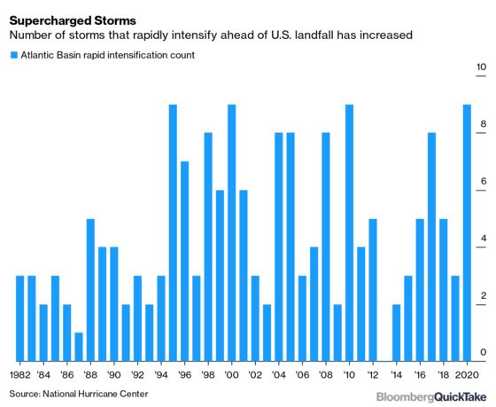
2. When has it happened?
Multiple studies have shown that rapid intensification has become more common over the past three decades, pushing more large storms to become even stronger. In 2020, nine storms rapidly intensified ahead of U.S. landfall: Hanna, Laura, Sally, Teddy, Gamma, Delta, Epsilon, Zeta and Eta. It happened with two of the most devastating storms to slam American shores in recent years: In the 24 hours before Hurricane Harvey made landfall in 2017, for example, its winds jumped from 90 mph to 130 mph — the difference between a Category 1 storm and a Category 4 storm, while in 2018, Hurricane Michael’s winds increased in speed by 45 mph in the last 24 hours before landfall in Florida.
3. What’s the impact?
Surprise can be deadly. Hurricanes that quickly gain power are more likely to catch people unawares, with catastrophic consequences. When Hurricane Laura went from a Category 1 to a Category 4 storm in less than 24 hours, projections of its storm surge jumped from 11 feet (3.4 meters) to 20 feet, and some Louisianans intent on riding out a weaker storm were forced to make an 11th-hour decision to evacuate. In 2015, 33 crew members on a cargo ship called El Faro drowned when they set out to sea based on forecasts of a weak tropical storm, only to have it balloon into a Category 4 monster in less than 24 hours.
4. What’s causing the change?
The reason hurricanes are getting more powerful with such speed is no secret: warmer ocean water. “It’s a known effect of climate change. Increasing ocean heat is causing strong hurricanes to become stronger,” said Greg Foltz, an oceanographer with the U.S. National Oceanic and Atmospheric Administration. “Surface temperatures in the Gulf now are about 0.5° Celsius to 1°C above the 1971 to 2000 mean. This gives more fuel to hurricanes and increases their wind speed limit.”
5. Can anything be done about this?
The ultimate question is what steps are taken to limit climate change. But better forecasting and better understanding of storm mechanics can lead to timelier warnings. The supercharging of Hurricane Ida was less of a surprise than Laura’s, in part because of changes made to a network of floating ocean temperature sensors known as Argo, run by an international consortium of scientific agencies. This year, NOAA increased the frequency of reports from the Argo floats, to every two days instead of every 10. With more timely information, NOAA forecasters saw that Ida was headed toward a very warm blob of subsurface sea water. If the deep water in the path of a storm that’s churned up by surface winds is cold, it tends to reduce the storm’s power.
The Reference Shelf
- NASA covers hurricanes, typhoons and tropical cyclones on its precipitation page.
- Trackers from the National Hurricane Center and Central Pacific Hurricane Center.
- Bloomberg Opinion’s Francis Wilkinson asks if U.S. taxpayers are willing to save the Jersey shore, and a podcast by Justin Fox on climate change geography.
©2021 Bloomberg L.P.