Tornadoes and Baseball-Sized Hail Threaten Texas, Oklahoma
Tornadoes and Baseball-Sized Hail Threaten Texas, Oklahoma
(Bloomberg) -- A powerful spring storm is bearing down on Texas and Oklahoma, bringing tornadoes, flash floods and baseball-sized hail, threatening crop planting and boosting prices.
The system could deliver as much as 5 inches (13 centimeters) of rain and hurricane-force winds, according to the National Weather Service, as it sweeps through regions peppered with oil and natural gas facilities and wheat fields. Some areas could get as mto 15 inches, Patrick Burke, a senior branch forecaster at the U.S. Weather Prediction Center, said in an interview.
“It’s going to be a dangerous weather-day out in the Great Plains,” Burke said. “It will be a really long day in Oklahoma City in particular.”
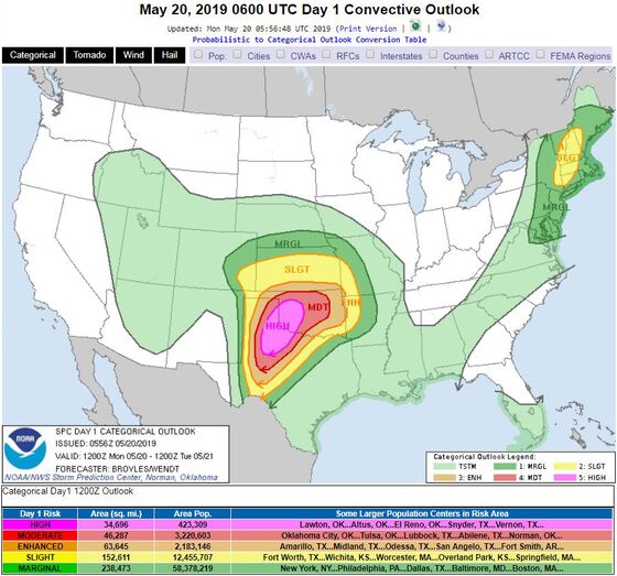
The Great Plains and Midwest have been battered by storms this year, leaving the Mississippi River at dangerously high levels, causing record floods in Nebraska and Iowa and delaying corn and soybean planting across the region. Oklahoma has been home to some of the nation’s worst tornadoes. On May 20, 2013, dozens were killed when an EF-5 twister, the strongest on the Enhanced Fujita scale, ripped through center of the state.
Tornado warnings popped up across Texas and Oklahoma late Monday as weather service radar began picking up rotation in the atmosphere and cautioned residents against quarter- and golfball-sized hail. Earlier in the day tornadoes were reported in Texas and Arizona. Hail broke windows in Lipscomb, Texas and was also reported in Missouri and Oklahoma, according to the Storm Prediction Center in Norman, Oklahoma.
High winds lifted boats out of the water and damaged them in Delaware, Oklahoma.
U.S. wheat and corn futures climbed on supply concerns amid the deluge, with hard red winter wheat jumping as much as 4.6% to a one-month high of $4.3975 a bushel.
“The weather forecast is also calling for heavy rains through all of Kansas and could be a cause of crop loss,” Zaner Group market strategist Brian Grossman said in a message. Kansas is the top U.S. wheat state.
The oncoming system has spawned thunderstorm, flood and wind watches and warnings from New Mexico to Missouri. The worst of it is expected to hit north-central Texas and Oklahoma. The storm may spill into Kansas and Arkansas over the next 24 hours.
For wheat crops, baseball-sized hail typically causes less damage than pea- or marble-sized hail, said Mark Hodges, executive director of Stillwater, Oklahoma-based marketing association Plains Grains Inc. Smaller hail accompanied by extreme winds can break stems and knock over plants, while larger hail, which causes more property damage, often is less widely dispersed and has a greater chance of missing crops.
“A lot of heavy rain along with wind could be just as problematic,” Hodges said by telephone. “In most areas of the state, we don’t need any more rain.”
Afternoon heat will create more instability in the atmosphere, allowing the storm to strengthen. Some tornadoes could be long lasting, increasing their impact.
“This is a classic, severe-weather-outbreak pattern,” Burke said. “The most dangerous weather will come in the afternoon hours and continuing through the night time. We are very concerned.”
To contact the reporters on this story: Brian K. Sullivan in Boston at bsullivan10@bloomberg.net;Michael Hirtzer in Chicago at mhirtzer@bloomberg.net
To contact the editors responsible for this story: Tina Davis at tinadavis@bloomberg.net, Millie Munshi, Pratish Narayanan
©2019 Bloomberg L.P.