(Bloomberg Opinion) -- In coastal Texas and many other places, walled cities are making a comeback. It’s quite a turnabout, as the efficacy of defensive walls had declined precipitously since the age of the long bow. Barbarians still menace, of course. But the rekindled enthusiasm for defensive walls is a response to a different kind of threat.
San Francisco is contemplating a huge tidal wall across its bay to fend off sea rise and the attendant dousing of some of the world’s most expensive real estate. Miami is weighing the damage a sea wall would do to tourist vistas against the damage a rising sea might do absent a wall. New Orleans, after $14 billion in levee construction, is an armored metropolis. Norfolk, Virginia, another low-lying city exposed to a surging sea, is spending a few hundred million federal dollars on a downtown sea wall. New York City, which has flooded in two devastating storms so far this century, is building a $1.45 billion series of walls, floodgates and underground drainage, a modest down payment on the city’s defense against rising tides and storm surge.
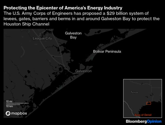
In March, I spent a storm-soaked day driving the Texas Gulf Coast with three members of the Army Corps of Engineers. Galveston Bay and its coastal environs is the focus of the largest Army Corps proposal in history: a vast array of walls, gates, barriers and berms. The project would cover so much terrain that a nearly nine-hour tour wasn’t sufficient to take it all in. It’s so expensive that the current $29 billion price, recently increased from $26 billion, is universally regarded as a short-term estimate. The projected cost, calculated in 2020 dollars, doesn’t factor inflation or include a few billion in ancillary construction.
The unprecedented scale and expense suggest that a national reckoning with climate change has truly begun. It’s not the reckoning that climate activists and scientists had clamored for — a radical reduction in greenhouse gas production to keep global temperatures in check. Instead, it’s a reckoning with the reality that it’s 2022, and carbon, like global temperatures, is still burning hot.
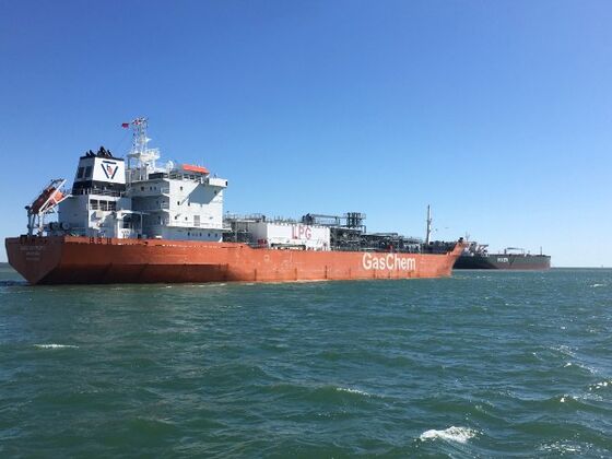
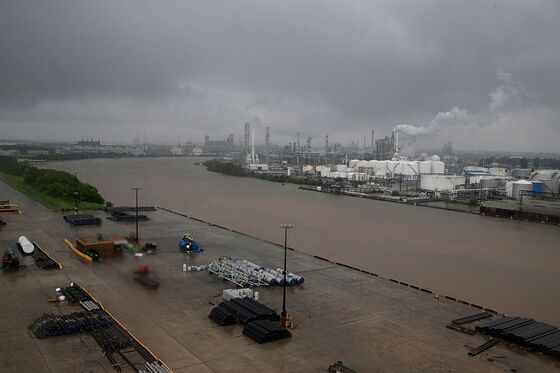
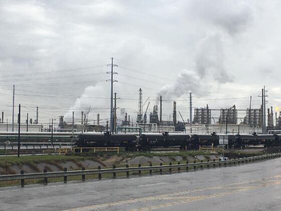
Even in Texas, home to almost one third of the nation’s petroleum refining capacity, denialism is running out of rope. Plans for a vast coastal defense of Texas aren’t just a testament to the world’s persistent demand for fossil fuels — they’re an acknowledgment of the grim consequences of it. The Houston Ship Channel, which courses for 52 miles through Galveston Bay, from the Port of Houston to the Gulf of Mexico, is the egress for more than a million barrels a day of crude. About 700,000 tons of petroleum products flow through the channel each year.
On the Bolivar Peninsula, a breezy ferry ride from Galveston, oil derricks pump within sight of the beach. On the industrial highway from Houston to Galveston, smokestacks and pipelines protrude everywhere. Houston alone accounts for 42% of the nation’s petrochemical capacity. In effect, the nation’s carbon energy capital is seeking protection from a sea and sky broiled by its own manufacture.
This region was clobbered by Hurricane Ike in 2008 and drenched by Hurricane Harvey in 2017. Each storm brought death, destruction and billions in cleanup costs. (Ike cost Texas an estimated $29 billion, equivalent to the projected cost of the Corps’ main coastal defense plan.) Yet each storm also represented a bullet dodged. Given the concentration of petrochemicals around Galveston Bay, any major storm has potential for a long toxic aftermath.
Perhaps in other locales, greener living and organic defenses still have a fighting chance. Even around Galveston Bay, some argue for fewer walls and more marsh and dunes and oyster beds. But on the Texas coast, where hurricanes are already fierce and frequent, and where the land sinks as the water rises, it’s getting late for that. It’s down to steel and money now.
***
It took six years and more than $20 million just to study the Texas coast and produce recommendations for armoring it. The Corps completed its report last September and subsequently forwarded it to Congress. If Congress begins funding the project later this year, and keeps funding it until conclusion, the whole thing should be wrapped up by 2040 or so, provided Texas and the state’s coastal counties come up with their share — about one third — of the total cost.
The centerpiece of the project, and its costliest component, is a surge barrier system across the Bolivar Roads, the gaping mouth where Galveston Bay opens to the Gulf of Mexico. (The barrier is sometimes called the “Ike Dike,” a term coined by a Texas A&M professor, after the 2008 hurricane.) The Corps says the system, which would stretch from the east end of the barrier island of Galveston across to the west end of Bolivar Peninsula, combines “sector gates, vertical lift gates and shallow water environmental gates that tie in to the shoreline with combi-walls and levees.”
For a sense of scale, the 15 vertical lift gates, which account for only part of the contraption, are each 300 feet wide. Together, they span a distance greater than 12 football fields.
Sea level along this coast is up about 18 inches since the middle of the last century. Forecasts for the middle of this century anticipate a rise of another 12 to 26 inches. Hurricane winds can cause enormous damage but the Corps is mostly focused on repelling the surge that accompanies such storms, which grows more dangerous with sea rise. The Corps’ design allows for barriers to rise if sea rise exceeds expectations.
Kelly Burks-Copes is the Corps’ chief of the Program Support Branch for the Mega Projects Division, a title she wears with grace and humor. But the “mega” part is no joke. In addition to Galveston her portfolio includes plans for a $4 billion series of defenses against storm surge that includes a pumping station, levee and flood wall in Orange County, about 100 miles east of the Bolivar Roads barrier. Like Houston, Orange County is home to enormous chemical plants, and those plants are also vulnerable to surge.
The Bolivar Roads barrier is designed to block surge from the Gulf before it enters Galveston Bay and pulses toward bayside industry. The barrier’s elliptical-shaped vertical gates will remain suspended in air between concrete towers that rise nine stories above the water line. Hydraulic cylinders and pistons — which, like everything about the wall, require regular and costly maintenance — will enable the gates to glide up and down the towers as needed. The full dimensions of the gates will depend on where they are placed: Galveston Bay has varied depths, running about 40 feet near Galveston Island to around half that toward the Bolivar Peninsula side of the bay.
By themselves, the vertical gates would constitute an enormous public work. But they are only one element of the plan, and not the most complicated.
That superlative belongs to the fan-shaped, floating sector gates. Those gates will be housed on three parallel man-made islands. The two sea lanes formed between the three islands will be dredged to create two ship channels, one running in each direction from Houston to the Gulf. Here’s how the Corps describes the gates’ operation:
Normally, each gate will sit in a dry dock (underwater chamber) in its respective island, but when a storm is approaching, the dry docks will be flooded, allowing the gates to swing out and float into place. Water will then be pumped inside the hollow gates, which will cause them to sink down to the bottom and close the channel.
Each gate will be 82 feet tall, which is almost eight stories high. When closed, 60 feet of the gates will be hidden below the water, with only 22 feet of the gates visible above the water. Once the storm has passed, the water will be pumped out of the gates, and they will be floated back into the artificial islands for storage.
Dutch engineers, the cool kids of coastal engineering, were consulted on the system. But the nearest cousin to the gates planned at Bolivar Roads isn’t in the Netherlands; it’s a barrier system in St. Petersburg, Russia.
St. Petersburg, on the shores of Neva Bay in the Gulf of Finland, has been inundated hundreds of times in its history. The 16-mile St. Petersburg Flood Prevention Facility was constructed from 1979 to 2011 to keep the city from going under. The centerpiece of the project is two 130-meter curved gates that function similarly to the gate system envisioned by the Corps in Galveston Bay. So far, the system seems to work; flooding in St. Petersburg has been reduced.
It’s not hard to understand why U.S. Army coastal engineers are giddy with anticipation over the Texas Coastal project. It’s historic, complex, vast, expensive and, ultimately, life-saving. Yet it’s equally obvious why some environmentalists are alarmed. The project could be immensely disruptive. Any intervention on that scale seems certain to have unintended consequences for the bay’s delicate ecosystem. Within the Corps’ hulking, mechanized vision of the coastal future, it can be hard to see a safe harbor for nature.
***
When Europeans first appeared in the Gulf of Mexico, they noted that some of the natives who lived along the coast were large, strong and remarkably healthy. The Gulf offered a cornucopia of fish, crab, oysters and other nutrition; its estuaries teemed with life. Those who lived along its shores were less likely to go hungry and malnourished than members of many inland tribes — or of European nations.
The subsequent destruction of the Gulf environment was as wanton as elsewhere in the New World. Fish were netted by the ton, and tons were thrown back, dead, into the water. Native birds — egrets, herons, flamingos, spoonbills — were slaughtered for their plumes, which ended up on Victorian ladies’ hats. Entrepreneurs descended on Pelican Island, adjacent to Galveston, and killed all the pelicans. The birds were boiled for their oil, though as Jack E. Davis notes in “The Gulf: The Making of an American Sea,” no market for pelican oil ever emerged.
Oil has been integral to the coastal Texas economy for more than a century. When the Deepwater Horizon rig ruptured in the Gulf in 2010, spewing a couple hundred million gallons of oil over 87 days, it did not mark the end of an era. It merely confirmed the extraordinary price that the oil and gas coast is willing to pay for its industrial way of life.
Environmentalists in Texas tend to be mindful of the region’s history, and work within its contours. I met Bob Stokes, the president of the Galveston Bay Foundation, at his group’s temporary headquarters in Kemah, a bayside town between Houston and Galveston. Kemah is only 15 miles north of Texas City, a grim industrial port that handles 40 million waterborne tons of freight a year. The port’s largest exports are gasoline, diesel, jet fuel, chemicals and petroleum coke.
Given the vulnerability of the bay’s toxic neighbors, Stokes said, he agrees with the Corps that “something does have to be done.” But he fears the Corps’ two-decade timeline leaves the region exposed to catastrophe in the near term.
Stokes is not alone in faulting the bay barrier plan for being simultaneously too much and not enough. “Even today, if it were up and running, it would not withstand a Category 4 storm,” said Amanda Fuller, director of the Texas Coast and Water Program for the National Wildlife Federation.
Hurricanes are categorized by wind strength, not surge level, which is what the barrier system is designed to repel. Most people I spoke to believe the region’s industrial infrastructure is significantly better equipped to withstand high winds than a high surge. Still, the intensifying power of storms means the question, and the threat, is far from resolved. “We’ve lost so much opportunity over the last many years focusing on this shiny object instead of really having meaningful policy discussions about how the state is going to address the impacts of climate change on the coast,” Fuller said.
Fuller argues for blunting the force of future storms by more natural means — bolstering dunes and expanding marsh and oyster beds to slow storm surge. Stokes wants to see more robust safety measures in place soon. “Our thought is that we should be spending a fraction of the cost in the short term to ensure that industrial facilities around the bay are as protected as possible,” Stokes said. “Then, for folks who are subject to storm surge, elevate their homes. It might cost 50, 75, 100 thousand dollars on a per-house basis, but you’re still spending a fraction of what you’re going to spend on this multibillion-dollar project.”
Both Fuller and Stokes have unanswered — and, for now, perhaps unanswerable — questions about the project’s environmental impact. The Corps is required to address serious environmental concerns. But under the National Environmental Policy Act (NEPA), it can do so in a “tiered” fashion, as the project evolves, rather than fully resolving all questions prior to the start of construction.
“There are essentially three layers of environmental concern,” Stokes told me. “The first is tidal flow in and out of the tidal prism of Galveston Bay. When water is restricted in and out of Galveston Bay, our high tide gets a little bit lower and our low tide gets a little bit higher. Because there’s not enough time for the same amount of water to flow. So you’re going to lose fringe wetlands on the edge of Galveston Bay at both extremes.”
Loss of wetlands initiates an array of environmental damage, and reduces the natural resistance to surge. But the Corps can at least mitigate wetlands loss in one place by cultivating wetlands elsewhere. A more complex issue may be the flow of water between the bay and the Gulf through Bolivar Roads, where the gate system will be positioned. “Water flows in and out of Galveston Bay pretty easily right now,” Stokes said. “We have this massive industrial and residential complex of 7 million people who drain right into Galveston Bay, yet we still have pretty decent water quality in no small part because we get a lot of circulation.”
A barrier across Bolivar Roads would constrict that flow. The Corps initially estimated that flow would be reduced around 27%. After a redesign, however, the Corps says less than 10% will be curtailed, and the impact will be negligible. Stokes is not so confident. “If you restrict that flow, you could have more algae blooms or just poor water quality,” he said.
Stokes’ third major concern is the effect on the rich estuaries of the bay and gulf. “Pretty much all of our fish, shrimp and crabs spend some portion of their life cycle in the bay and some portion in the Gulf of Mexico,” Stokes said. “They rely on floating in and out of the bay on the tides.” If construction forces 100% of the water flowing between bay and gulf into 90% of the area, the result will be higher pressure and increased speed. “So what happens to the larval and post-larval and juvenile fish, shrimp and crabs that are floating back and forth?” Stokes asks. “These are all concepts that the Corps knows about, but they’ve sort of deferred real analysis of them because they’re doing this tiered environmental analysis under NEPA.”
Fuller and Stokes aren’t the only people offering alternatives to the Corps’ vision. Rice University in Houston hosts the Severe Storm Prediction, Education & Evacuation from Disasters Center, a research consortium dedicated to mitigating regional storm damage.
SSPEED director Phil Bedient has been championing the Galveston Bay Park Plan, which includes a barrier at the opening of Galveston Bay while also calling for construction of barrier islands to form a 25-foot levee running parallel to the Houston Ship Channel. The point is to armor the industrial corridor on the west side of the bay, leading to Houston, and repel surge across to the less populated, less industrial eastern side of the bay. “We’re protecting against a major hit,” Bedient told me. “It ties into the Texas City dike, which would also be elevated to 25 feet. So you’re protecting all of the ship channel and all of the petrochemical center of Houston.”
It is difficult, however, to win a war against the U.S. Army. The Corps has power and resources unmatched by other groups vying for a role in coastal protection. It has access to millions in planning funds and to deep institutional expertise. Most important, it has the inside track to billions in federal aid.
The promise of federal subsidy for local benefit is the surest means of generating, and sustaining, regional consensus around a plan. Industry naturally prefers to offload the cost of storm protection to taxpayers. Construction and maritime trades are eager for a long and steady flow of high-paying jobs. Homeowners want their property safeguarded at public expense. State and local officials, meanwhile, want it all: protection from natural disaster, an employment boost for local workers and the political glory that flows from a gargantuan public works project, all while shifting two-thirds of the tab to taxpayers who vote in someone else’s election.
***
Galveston was almost erased in 1900. A hurricane — likely a Category 4, with winds surpassing 130 miles per hour — struck the island head on. As the water rose, residents huddled in terror on the second floors of homes. The wind dismantled their defenses, removing roofs and siding, deconstructing houses in roughly reverse order from the sequence of framing and finishing. Storm surge, estimated at more than 15 feet, levered homes off their foundations, setting them loose in the roiling tide. Cast into the surf, victims were pummeled by water-borne objects, impaled on trees, decapitated by flying shingles. Some were simply swept away, never to be seen again. More than 6,000 died, though a definitive accounting is impossible.
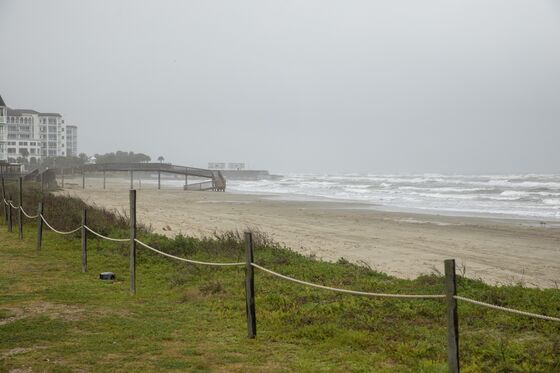
In a remarkable feat, the city responded by raising the island, spending a decade elevating 2,000 buildings atop 11 million pounds of fill. To contest the sea, it built a wall, facing the Gulf, behind a first-line defense of beach and boulders. From the waterline across a sloping beach to the top of the wall was a gradual rise of about 17 feet. According to official Galveston tourism patter, “Today, the iconic Seawall Boulevard is a happening place for beachgoers and serves as a gorgeous backdrop to a variety of shops, restaurants, attractions and gear rental stores.”
By the time I reached the sea wall with my Army Corps of Engineers guides, the wind had already lifted my baseball cap off my head and into Galveston Bay. It was that kind of day. Rain stopped and started but never lightened its mood. Visibility was poor and the sky was layered in dense packets of grey. The wind carried the smell of the Gulf, which percolated with white caps and intimations of power. The next morning, a tornado passed by Galveston, blackening the sky on its way to visiting destruction on Louisiana.
As the sea rises, barrier islands like Galveston won’t offer much defense. “They’re not very tall, they’re eroding fairly aggressively and so they’re kind of marching back,” said Kelly Burks-Cope, the Army Corps project manager. “Eventually, with about three feet of sea-level rise, they’re underwater and it opens the entire mainland to the Gulf.”
The old sea wall in Galveston, which does double-duty as a waterfront road, will need to be raised, and new walls, protecting the island from the bay side, will have to be constructed. The bay will have to adapt to an altered environment.
Houston is one of the busiest ports in the nation. More than 70 ships were docked on the day I joined some Houston port pilots on an eight-passenger shuttle boat that takes pilots to and from their jobs guiding containers through the ship channel. The bay is large, 600 square miles, and is subject to the whims of wind and current and fog that increase a pilot’s degree of difficulty. When piloting a ship 800 feet long and 145 feet across, packed with petroleum or chemicals, the stakes rise. In 2014, a barge crossing the ship channel collided with a cargo ship. About 4,000 barrels of oil spilled.
Hurricane Ike in 2008 roared right up the Houston Ship Channel, destroying its navigation aids. About 150 ships were stranded while the Coast Guard remapped the channel over several days. Bolivar Roads, where the Army Corps plans the sea gates, is where many ships linger as they await a pilot. When the barrier goes up, ships will have to wait further out in the Gulf. And when a pilot guides a ship through the sea gates, the vessel will be subject to the same accelerated current that has Bob Stokes fretting over crab and shrimp.
Because so much industry and commerce front the bay, and because those businesses are loath to lose ready access to water, Galveston’s new wall — a “ring barrier” around the city — is planned to run alongside a road rather than along the bulwarks. Businesses by the bay will be exposed to flood. And then they will be exposed to the rebound when the surge hits the wall and flushes back toward the bay. Streets leading from the bay will have their own gates, which can be closed in a storm.
Not every home in Galveston will be protected. Near one cluster of houses, for example, a road will be constructed to carry residents over the new wall to relative safety, leaving their homes to face the surge.
The Corps is not in the business of happenstance. Its decisions are plotted against a grid of engineering and politics, money and danger, probability and fear. The changes it envisions to the coast are profound. Drivers on Galveston’s Harborside Drive, for example, will no longer be harbor-side. They will be wall-side. The sense of space will be altered, and one of the grace notes of island life — constant proximity to water, the feeling of openness and access and flow — will be muted.
Back when climate scientists first began discussing the need to displace fossil fuels, and to change the American lifestyle to mitigate the worst damage from carbon, walled cities were not what they had in mind. But on the carbon-energy coast of Texas, with the future and the sea closing in, walls appear to be the inevitable result.
Not everything will be different. The sea air will still permeate. The sand, while it lasts, will still beckon. And from atop the sea wall, people will still watch the tankers ply the ship channel, their elevated view the price of the vessels’ uninterrupted progress.
This column does not necessarily reflect the opinion of the editorial board or Bloomberg LP and its owners.
Francis Wilkinson writes about U.S. politics and domestic policy for Bloomberg Opinion. He was previously executive editor of the Week, a writer for Rolling Stone, a communications consultant and a political media strategist.
©2022 Bloomberg L.P.