Saildrone’s Journey Around Antarctica Uncovers New Climate Clues
Saildrone’s Journey Around Antarctica Uncovers New Climate Clues
(Bloomberg Businessweek) -- The robot sailboat is called #1020. It’s a lackluster moniker for a machine that just spent seven months battling its way through 12,500 miles of frigid, massive waves to circumnavigate Antarctica. The robot, made by startup Saildrone, is the first of its kind to complete the harrowing journey. More important, it’s the only scientific vehicle to have captured such a detailed environmental picture of the state of the Southern Ocean, bringing back data that could be key to our understanding of climate change.
Scientists have long viewed the Southern Ocean as a major carbon sink, meaning it pulls carbon dioxide out of the air and pushes it deep underwater. About 40% of the 2.5 billion tons of carbon the ocean absorbs every year is thought to make its way into these waters around Antarctica, says Bronte Tilbrook, a scientist who studies the region on behalf of CSIRO, Australia’s national science agency. This process helps in removing carbon dioxide that causes warming in the atmosphere, although it also contributes to increasing the acidity of the oceans. The truth, though, is that scientists know precious little about exactly how the Southern Ocean operates, because it’s been such a difficult spot to measure.
Each year, a few ships make journeys to points in Antarctica and take measurements along the way. Their routes are limited, and they typically sail only in the warmer months. Over the past few years, more data has been gathered from a series of scientific floats that measure the acidity of the water near them and then infer amounts of carbon dioxide from this data. As with the ships, the data points are sparse and provide a vague picture of the environmental conditions around the entire continent. “We have such a limited amount of data to assess the Southern Ocean,” Tilbrook says. “There are vast areas where no measurements have ever been made.” The idea of sending something like a drone to take continuous measurements in all areas and across all seasons had been thought impossible, because of weather and ocean conditions, until Saildrone came along.
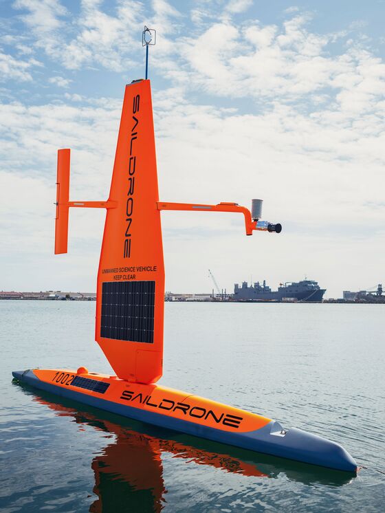
Founded in 2012, Saildrone operates a fleet of dozens of bright orange robotic sailing vessels. Rather than having a cloth sail, they rely on something more akin to a plane’s wing. The company gives each drone a destination, and off it goes, sailing and tacking on its own. The drones are packed with hundreds of thousands of dollars’ worth of scientific equipment to measure things like currents, dissolved oxygen levels, water temperature, acidity, and salinity and operate for a fraction of the cost of traditional research vessels. Meanwhile, sonar and acoustic instruments are used to pinpoint animal life and produce data on fish stocks, for example. Saildrone’s ultimate goal is to have as many as 1,000 drones constantly sailing the oceans to provide a real-time accounting of what’s happening in the world, plus invaluable data about the weather and the environment.
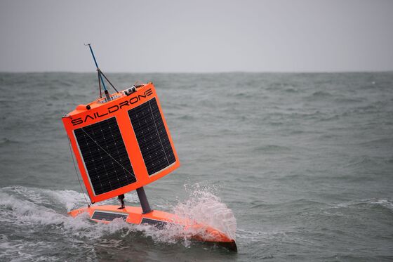
On Jan. 19, Saildrone released three drones from the southern tip of New Zealand to attempt the voyage around Antarctica. Storms soon battered two of the drones, forcing them to struggle back to New Zealand for repairs. (They were sent out again in April.) But #1020 was designed with a shorter, squatter, rectangular sail rather than the usual lofty, triangular shape. The craft measures 23 feet long with an 8-foot-high sail. “We had been there before and learned to engineer something specifically for the Southern Ocean,” says Richard Jenkins, the company’s co-founder and chief executive officer. “It’s like a brick shithouse and incredibly strong.” During its journey, the drone withstood 50-foot waves and 80-mph winds. At one point, it rammed into an iceberg, which killed some atmospheric sensors and the onboard camera.
Even without the camera, Jenkins could monitor #1020’s path via location-tracking devices and see that it was doing OK. The drone has now crossed every line of longitude, meaning that in some sense it has also circumnavigated the globe. On Aug. 3, it returned to New Zealand, where Jenkins and his team lifted the bruised and battered robot out of the water and downloaded huge stores of data gathered by its carbon dioxide sensor, which was designed by the U.S. National Oceanic and Atmospheric Administration.
Scientists from NOAA and other research agencies have been eager to take a look at Saildrone’s data. Recent information gathered from the existing floats has led to a big debate among researchers, with some of them claiming that the Southern Ocean might not be storing nearly as much carbon as previously thought. But since the floats measure only acidity, are relatively sparse, and went into the water only recently, the data set is incomplete and possibly anomalous. “The Saildrone mission is really exciting to me because we are measuring the CO2 directly and can compare the results to the floats,” says Adrienne Sutton, an oceanographer with NOAA. “But we still need to answer questions about variability over time and area and need a lot more devices down there.”
Having looked at some preliminary Saildrone data, NOAA scientists observed the Southern Ocean actually releasing carbon dioxide during the winter months—a fact that could have major implications on climate models. Of course, there’s much analysis work and measurement left to be done before answers emerge. “We still don’t fully understand the ocean’s natural carbon cycle, much less the human influence on it,” says Christian Meinig, director of engineering at NOAA’s Pacific Marine Environmental Laboratory. “We are trying to solve two puzzles at once without enough information. Sorry to be a downer.”
Tilbrook, the Australian scientist, also hopes to review the data. “Over the next 20 years, we can expect very big changes in the Southern Ocean ecosystems,” he says. “The message is that the Saildrones work and can survive and that now we need more data.”
The Li Ka Shing Foundation, a charitable organization backed by the Chinese billionaire, paid for this mission. In addition to the Saildrones, it helped set up an educational program for young students, many of whom have been following all three drones and learning about the science behind them. Moving forward, Jenkins expects to have a fleet of drones constantly circling Antarctica, measuring not only carbon dioxide but also things like krill stocks and temperature. The plan then is to make the data available to the public and run a contest with a $1 million prize for “the most transformational work” done with it.
“We need a mathematical model than can predict the ocean’s uptake of carbon,” Jenkins says. “It’s freaking 38 degrees centigrade in London. This is not a coincidence. Are we experiencing a runaway effect from carbon? We need to know the answer, and we really have to accelerate the rate at which we do the research.”
To contact the editor responsible for this story: Jeff Muskus at jmuskus@bloomberg.net, Mark Milian
©2019 Bloomberg L.P.