Why It’s So Hard to Identify the Ship (Maybe) Behind California’s Oil Spill
Why It’s So Hard to Identify the Ship (Maybe) Behind California’s Oil Spill
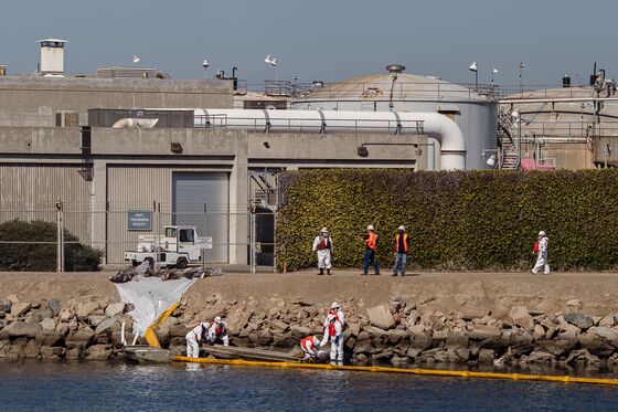
(Bloomberg) -- The hunt for the ship that may have caused last week’s major oil spill off the coast of Orange County in California is proving to be a slow grind.
Assuming an anchor caused the pipeline tear—and that’s seen as the likeliest explanation—at least seven ships passed over the area in question between 5 a.m. and 7 p.m. local time last Friday, according to SkyTruth, a nonprofit that uses satellite imagery for environmental protection. Once those ships are identified, the Coast Guard will likely want to board each one, interview the crew and examine the navigation systems, like it did for the one cargo vessel in the vicinity it has already cleared.
“The Coast Guard is looking into several vessels at this time,” Coast Guard officer Sondra-Kay Kneen said by email. “To ensure the integrity of the investigation we will not be releasing individual names of vessels.” The Southern California Spill Response, which includes the Coast Guard, California Department of Fish and Wildlife, Orange County and pipeline owner Amplify Energy Corp., said earlier it's “analyzing electronic charting systems from our vessel traffic service to see what ships were anchored or moving over the spill area.”
In a world where real-time monitoring of ship locations has been available for years, the painstaking detective work of combing traffic logs and questioning crew members to solve the cause of one of the worst oil spills off the California coast in decades may seem tedious. But there’s so much about the pipeline spill that’s still unknown, including whether the pipeline was even in its expected location at the time of the possible anchor snag, said SkyTruth President John Amos.
“Maybe it got moved a long time ago, or got moved in multiple strike events,” he said in an interview. “Maybe it was moved and stressed and didn’t fail. But at the stress point, you will have accelerated corrosion.”
SkyTruth has emerged a major source of information about the spill, using satellite imagery and other public information to pinpoint the probable time when oil started bubbling to the surface and the ships that may have been involved. The group—which is not part of the official investigation—has drawn attention for arguing that the spill began much earlier than thought.
Amplify shut down the line and reported the spill on the morning of Saturday, Oct. 2. But the pipeline was most likely damaged before 7 p.m. on Friday as an oil slick was visible, Amos calculates. The first report of an oil sheen on the water was submitted by a nearby vessel to the National Response Center at 6:13 p.m. on Friday.
The ships that sailed over the line that day included a 260-meter (853-foot) Maltese-flagged cargo vessel, a 68-meter (223-foot) U.S. military vessel, a 53-meter (174-foot) Coast Guard ship, a fishing boat and three pleasure craft, according to SkyTruth. A 4,000-foot section of the line was moved as much as 105 feet from its original position and divers found a 13-inch split in the line that’s likely the source of the release. The response team also released underwater videos of the pipeline, including the one showing the spot where the break in the pipeline happened. It didn’t provide the exact coordinates of the break, saying it was about six miles southwest of the seaside town of Seal Beach.
“One of the reasons that they are being very cautious about the information that’s being shared is that investigations like this could hold, not just civil liabilities, but potentially criminal liability,” Assemblywoman Cottie Petrie-Norris, who represent the area in the state legislature, said in a Thursday press conference. That’s “why they are being incredibly meticulous about building a case and, I think, incredibly cautious about the information that gets shared to the community.”
The direction the pipe moved, which has not yet been released, could give some indication of the ship’s direction, helping to identify it. “As far as direction, it appears to be a slight curve throughout miles and miles of pipeline. Hard to see in videos and pictures, but the pipeline is supposed to be straight,” Southern California Spill Response said in a text, without sharing the direction of the move.
Earlier in the week, SkyTruth flagged the cargo vessel Rotterdam Express as being near the pipeline break. The ship’s owner Hapag-Lloyd AG said on Thursday that the vessel was no longer under investigation and was en route to Mexico.
©2021 Bloomberg L.P.