New York and Washington Face Weekend Snow Before Rain Arrives
New York and Washington Face Weekend Snow Before Rain Arrives
(Bloomberg) -- A fast-moving storm will deliver some snow to New York and other East Coast cities this weekend before turning into rain and slush.
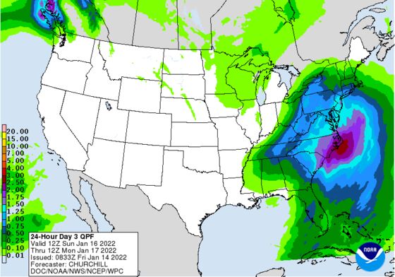
The storm will begin as snow in Washington late Sunday and reach New York overnight into Monday, according to Frank Pereira, a forecaster at the U.S. Weather Prediction Center in College Park, Maryland. Washington could get as much as 4 inches (10 centimeters) of snow, while Boston and New York may see closer to an inch or two before temperatures climb.
“For most of the I-95 corridor, like New York City, it will start out briefly as snow and then change over to rain,” Pereira said by telephone, referring to Interstate 95, a major East Coast highway.
As the storm develops late Saturday, it could bring a major ice storm to the Piedmont region of North Carolina and heavy snow to the mountains in the western part of the state. As much as a quarter inch of ice could coat the landscape, which often leads to power outages and transportation issues. Snow shut part of Interstate 95 in Virginia last week.
Up to a foot of snow could fall from there north into Virginia, West Virgina, parts of Maryland and Pennsylvania and into western and upstate New York. Northern New England will also get heavy snow, which will benefit ski resorts throughout the region.
What snow does fall in cities including Baltimore and Philadelphia will likely turn into slush before the storm ends. As the weather passes, temperatures in New York will rise from a low of 11 degrees Fahrenheit (-12 degrees Celsius) on Saturday to a high of 42 by Monday.
“The mountains are going to do well,” he said. “In the cities it is going to be a mess.”
©2022 Bloomberg L.P.