A $4.5 Billion Prize Draws Wireless Firms to Home of Feral Hogs
A $4.5 Billion Prize Draws Wireless Firms to Home of Feral Hogs
(Bloomberg) -- Workers are dodging bobcats and feral hogs as they crisscross Oklahoma’s westernmost sliver in trucks outfitted with electronic gear that tests wireless signal strength.
At stake are $4.5 billion in federal subsidies that small carriers across the country, including their employer, Panhandle Telephone Cooperative Inc., stand to lose if they can’t convince the U.S. Federal Communications Commission that their rural areas are inadequately served by telecom giants.
If their electronic survey can prove that Verizon Communications Inc.’s signal isn’t adequate, then the tiny, Guymon, Okahoma-based Panhandle will remain eligible for subsidies to bring wireless phone and internet service to underserved areas.
“We have no desire to bash Verizon, but we have to protect our interests,” said Shawn Hanson, chief executive officer of Panhandle.
Similar surveys are going on in rural areas across the country as small carriers look to protect their subsidies as the FCC rewrites the way the program is administered to focus on areas of true need.
Wireless companies used to win funding simply for operating where subsidies were paid to a wired network operator. But that resulted in some areas having multiple carriers getting subsidies, the agency says. The FCC is now trying to trim some $300 million annually in unnecessary funding from a program that will distribute $4.5 billion over the next decade.
Accurate Targeting
“Ongoing support is inappropriately and unfairly providing subsidies to multiple providers in the same area,” Mark Wigfield, an FCC spokesman, said in an email. The FCC wants to make sure that funds “are effectively and accurately targeted.”
Fast mobile broadband is either missing or is provided only by subsidized carriers in about one-fifth of the U.S. outside Alaska, according to the FCC.
To identify where there are gaps and where there is overlapping service, the FCC decided to map service areas. It ordered a confidential one-time submission of specified data from wireless providers to guide its map-making and then asked for comments from carriers such as Panhandle.
That resulted in accusations that some of the big carriers are exaggerating their service reach to keep small competitors out of the area -- and testing vehicles roaming the countryside to prove territories were still in need of subsidized service.
“It feels like a dominant carrier is using the regulatory process in an anti-competitive manner to try to run us out of business,” Panhandle’s Hanson said.
Verizon says critics are incorrectly measuring its signal, and that its maps were drawn to meet FCC guidelines.
Challengers get until late November to dispute the maps -- or face the prospect of being shut out of subsides for a decade.
That’s why workers for the Panhandle cooperative, at times using four-wheel-drive vehicles, have trundled over dirt paths and range land, past signs that say trespassers “will be shot” and that warn away archaeologists, conservationists and “rabid environmentalists.”
The workers carry mobile handsets that periodically feed reception data to laptop computers. On highways they need to roll below the speed limit, earning what the Panhandle cooperative in a filing politely termed “unfriendly hand gestures.”
Crews began driving in April, have driven more than 37,000 miles, and will keep it up through the fall, said Hanson.
“We just wanted the process to get it right, so that these very rural areas could continue to receive the support they need,” Hanson said. “We have to protect our oil and gas customers, our ranchers and farmers. Because without this support, these are very low traffic sites, where the volume of traffic would probably not even cover the electric bill.”
Panhandle is not alone in objecting to the FCC’s cartography. Farm bureaus in four states are lined up to challenge the new maps. Regulators in Illinois said it appears the maps leave almost no areas in that state would be eligible for funding.
By the end of July, 38 mobile providers had gained access to the mapping data held at the FCC, and the agency had taken in almost 1.7 million readings as challengers file their objections.
Nemont Telephone
In northern Montana, the Nemont Telephone Cooperative Inc. is sparring with T-Mobile US Inc., said Michael Kilgore, chief executive officer of the cooperative organized in 1950 by farmers wanting telephone service.
The rural area is among those that “since the beginning of time have been ignored by the dominant providers,” Kilgore said.
Subsidies helped Nemont build 80 towers, and that money may dry up if regulators accept T-Mobile’s claim of equal coverage from 12 sites, Kilgore said. “If our network gets shut down, who’s harmed by that? The customer,” he said.
T-Mobile representatives didn’t respond to requests for comment.
Ranch Reception
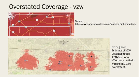
In Oklahoma, Hanson’s cooperative says it has 38 communications towers in the Panhandle compared with Verizon’s nine. Verizon provides a good broadband signal in about half the area it claims in the three-county Panhandle, according to Hanson.
Verizon says it’s following rules for mapping its coverage that were laid down by the FCC. In a filing it said Panhandle and its engineers ignore recent technological upgrades, and mistakenly ignore service from facilities in neighboring Kansas, Texas and New Mexico.
Consultants for the Panhandle cooperative in reply said they’re aware of the neighboring towers and criticized Verizon’s methods for drawing coverage.
The FCC’s effort has become a hot topic in Washington, where lawmakers fear rural areas are being left to languish as urban America profits from a communications boom.
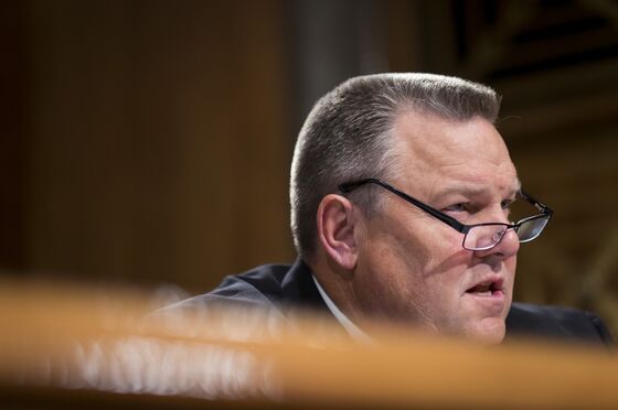
"The maps stink,” Senator Jon Tester, a Montana Democrat, said at an Aug. 16 hearing.
Providers “created this problem” by claiming widespread coverage, even in areas with dodgy reception such as his Montana ranch, Tester said.
The FCC’s map “dramatically overstates” existing coverage and is “known to be flawed,” said Senator Jerry Moran, a Kansas Republican.
Trespasser Warnings
Pai told senators the mapping procedure is more accurate than earlier assessments of broadband coverage, which relied on company estimates using varied yardsticks. This time the FCC required companies to apply a uniform approach, Pai told senators. Challengers get a chance to correct inaccuracies, he said.
"We don’t have the personnel -- the thousands of people -- that would be necessary to go around the entire United States,” Pai said.
Jessica Rosenworcel, the sole Democrat on the short-handed FCC, in an Aug. 21 statement said the maps “have too many inaccuracies to be reliable.” The FCC should call for help from other agencies that could sample signals, as could the people numbering over 200,000 who have downloaded a speed test app, Rosenworcel said.
Verizon said that if a company “disputes the model result in a particular area, it should follow the rules and file a challenge.”
“The FCC adopted the rules, and Verizon followed them,” the company said in the emailed statement Aug. 17.
The carriers such as Verizon didn’t take field measurements to generate their maps, but issued estimates using parameters established by the FCC.
The agency didn’t ask for the right data, said Steven Berry, president of the Competitive Carriers Association, a trade group with members including regional carriers whose funding could be threatened if the maps stand.
“Garbage in, garbage out. That’s what we have,” Berry said in an interview. “My gosh -- we can measure every crater on the frickin’ moon, and we have no idea where the broadband signal is in rural America.”
To contact the reporter on this story: Todd Shields in Washington at tshields3@bloomberg.net
To contact the editors responsible for this story: Jon Morgan at jmorgan97@bloomberg.net, Todd Shields, Elizabeth Wasserman
©2018 Bloomberg L.P.